Nature lovers can immerse themselves in a variety of outdoor, nature, and wildlife experiences in Bunbury, including largely flat, low- and medium-incline walking trails, an accessible lookout post at Maidens reserve, mangrove walks, and interactions with local wildlife.
Dolphin Discovery Centre
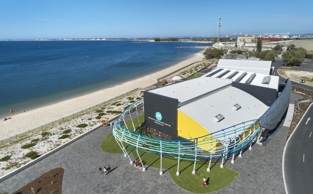
Koombana Drive, Bunbury. There is much to see and experience at this world-class attraction, from meeting friendly dolphins at the shoreline. Early mornings are the preferred time for the dolphins to visit the shoreline; however, as wild creatures, they have no set times or feeding. To get closer to these incredible marine mammals, book an eco cruise or dolphin swim tour (November to April).
For guaranteed underwater wonder, visit the Interpretative Centre at feeding time for the Turtle rehabilitation tank, the octopus tank, and the main fish/shark aquarium. The Dolphin Discovery Interpretive Centre is open 7 days from 9am to 3pm, with staff on site from 8am. (Entry fees apply).
Bunbury Wildlife Park

Prince Phillip Drive, Bunbury. Interact with wildlife right in the heart of Bunbury. With walk-through enclosures featuring a wide variety of friendly flight and land animals for an optimal interactive experience, the ‘farmyard’ offers visitors the chance to interact with animals such as kangaroos, emus, goats, sheep and alpacas. A reptile section is also housed at the Park, with a small display of snakes, goannas, lizards and frogs. (Entry fees apply).
Mangrove Boardwalk
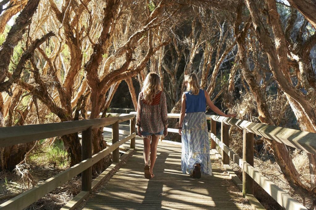
Leschenault Inlet, Koombana Park. The waterway contains an ancient mangrove community that represents the southernmost occurrence of the white mangroves in Western Australia. The Leschenault estuarine system is internationally significant with a high diversity of microfauna, a calm hatchery for fry and fingerlings (baby fish), surrounding vegetation in good condition and large numbers of migratory waterbirds protected under international agreements. Interpretive signage is located throughout the walk.
Basalt Rock Formations

Wyalup Rocky Point, cnr Symmons Street & Ocean Drive. Wyalup Rocky Point is a place of Indigenous significance. Wyalup means “place of mourning” as in the past, the area was a Noongar burial ground. The area is of significant heritage value and offers a dramatic, scenic location for viewing sunsets and waves. The basalt rock formations formed 130 million years ago during the breakup of Gondwana (India, Australia, and Antarctica), when molten lava flowed down an ancient river valley to the coast.
Free Overnight Rest Areas in Bunbury
Stay nearby at Bunbury's free overnight rest area near Wyalup-Rocky Point, suitable for self-contained RVs. Find out more.
Boulters Heights

Withers Crescent, Bunbury. Climb to the top of the refurbished pathways through bushland, a former dune, to take in a panoramic view of city landmarks and the waters of Bunbury. If visiting in the evening after 6pm, you'll see the Boulters Heights staircase light up with an array of rainbow colours.
Marlston Hill Lookout
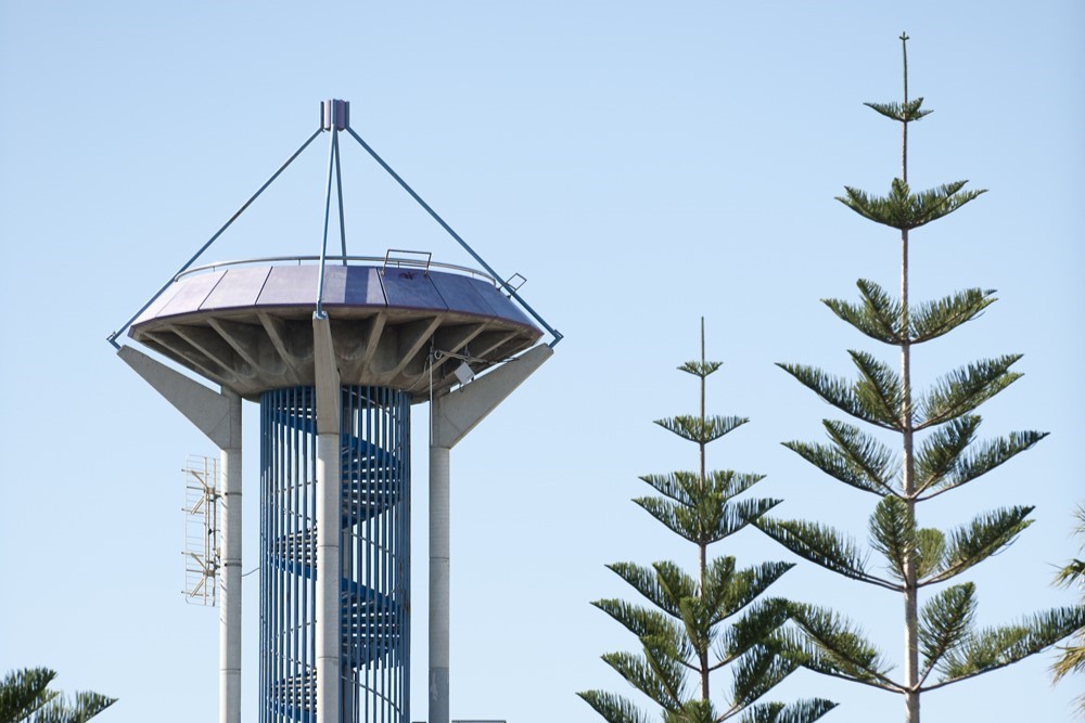
Whale View, Bunbury. The iconic lookout seen on the City of Bunbury logo is a climbable attraction, set atop Marlston Hill. Take a short flight of stairs from Victoria Street through a bushland enclave as it opens out into a small park and the lookout tower atop the hill.
Hiking in Bunbury: Nature trails
Feel like getting outdoors and stretching your legs? Take one of the nature walking trails in Bunbury. Bunbury is truly fortunate to have natural bush areas so close to the CBD where wildflowers can be found during the winter/spring months. *This information uses the common names for wildflowers
Maidens Reserve
Loading...
Ocean Drive. Sealed, gradual incline, accessible walkway through bushland to the first deck overlooking Bunbury, then 153 steps to the second lookout with 360-degree views to the Indian Ocean. Information boards on the flora and seating along the walkway. See more about the Maidens Reserve trail and lookout here.
The Big Swamp Wetlands
Prince Phillip Drive, South Bunbury. A 2km sealed walkway around a wetland, which is a haven for birdlife. Two boardwalks complete this area, one meandering through the paperbarks and the other including a bird hide. Seating is strategically placed along the walkway for birdwatching.
The Leschenault Inlet Walk
Stirling Street. 5km sealed walkway around the inlet, takes in the Mangrove boardwalk, information on the shipwrecks of the area and views over the inlet.
Manea Park
Sommerville Drive & Winthrop Ave, College Grove. A 2.2km circuit of compacted limestone through natural bushland. Habitat for flora and fauna, with native wildflowers in bloom from June to November. This is a favourite place for spotting orchids, from the early bloomers like snail orchids and rattle beaks to the end of season (October/early November) with blue sun orchids and in between with jug, spider, donkey, pink fairy, cowslip, enamel and kangaroo paws. Many bush varieties of wildflowers grow here too, Skinner's bush, native wisteria, hovea, and buttercups, to name just a few.
Tuart Walk
Cnr Ocean Drive & Mosedale Ave, Usher. A 1.2km sealed walkway from Bunbury to the town of Dalyellup, through bushland with a variety of native trees, including Banksia and Tuart. Many bush variety wildflowers are found here, with a sprinkling of orchids. False boronia, purple flags, cotton heads, native wisteria, purple tassels, donkey and pink fairy orchids.
Kathrine Chauhan Reserve
Cnr Parade Road & Guile F/way. This quiet reserve has a bush track meandering through to Sweeting Way. Blooming along the way are kangaroo paws, white spider, pink fairy, and cow slip orchids, along with bush varieties such as running postman, false boronia, buttercups and milk maids.